Overview
Ipswich Garden Suburb has been divided into three neighbourhoods - Fonnereau, Henley Gate and Red House (within Policy CS10 and the IGS SPD). Currently, two Outline Planning Permissions have been granted across the Henley Gate and Fonnereau Neighbourhoods totaling 1915 homes with supporting infrastructure. Below are details regarding the delivery of these three Neighbourhoods, information regarding the Housing Infrastructure Fund and the Ipswich Garden Suburb Delivery Board.
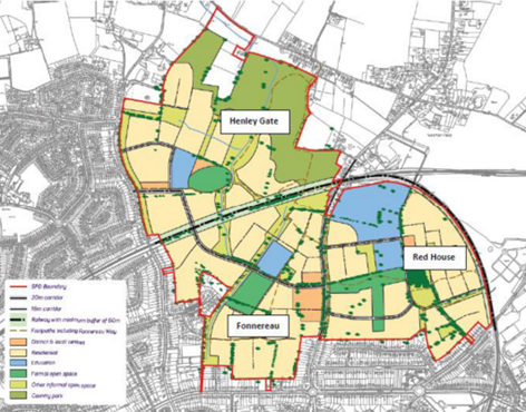
Fonnereau Neighbourhood
The Fonnereau Neighbourhood is located to the south of the railway line between Henley Road and Westerfield Road.
Outline Planning Permission was granted on the 31st January 2020 on part of the Fonnereau Neighbourhood (application reference- IP/14/00638/OUTFL). This grants Outline Permission for 815 dwellings alongside, a new primary school, a district centre comprising a mix of retail and office space, green spaces and a new community centre. This application was determined by Planning and Development Committee in April 2018 and a Section 106 Legal Agreement was completed on 30th January 2020.
The remaining part of Fonnereau Neighbourhood is on the Ipswich School playing fields.
Henley Gate Neighbourhood
The Henley Gate Neighbourhood is located to the north of the railway line, between Henley Road and Westerfield Road.
Outline Planning Permission was granted on 31st January 2020 on the Henley Gate Neighbourhood (application reference- IP/16/00608/OUT). This grants Outline Permission for 1100 dwellings alongside, a new primary school, a local centre comprising a mix of retail units and a new 30ha country park with a visitor centre. This development will also include 25 self build plots, a vehicular railway bridge and a pedestrian and cycle railway bridge. This application was determined by Planning and Development Committee in April 2018 and a Section 106 Legal Agreement was completed on 30th January 2020.
Red House Neighbourhood
The Red House Neigbourhood is located to the east of Westerfield Road and south of the railway line. An EIA Screening Opinion was provided by the Local Planning Authority in 2018 and EIA Scoping Opinion in 2019 on part of the neighbourhood.
A hybrid planning application, reference IP/22/00013/OUTFL, is currently being considered on part of the of the Red House Neighbourhood of the Ipswich Garden Suburb. The application seeks full planning permission for the two principal means of vehicular access and all pedestrian and cycle accesses off Westerfield Road and outline planning permission with all matters reserved for a mixed use development. The outline permission comprises up to 1020 dwellings (Use Class C3), a local centre (to accommodate up to 800 sq m of net floorspace within Use Class E (excluding Use Class Eg) and/or hot food takeaways and/or public house), a Primary and Early Years Facilities (both Use Class F1(a)); potential school vehicular access from Westerfield Road; cycle and pedestrian access from Tuddenham Road; provision of formal and informal open spaces and other landscaped areas and play areas; provision of infrastructure (including internal highways, parking, servicing, cycle and pedestrian routes, utilities and sustainable drainage systems); landscaping and engineering works (including ground remodelling and enabling works). The works proposed will affect Tree Preservation Orders within the application site. An Environmental Statement has also been submitted with the application under the Town and Country Planning (Environmental Impact Assessment) (England and Wales) Regulations 2017.
View the application and important dates for IP/22/00013/OUTFL.
Revised and additional details for this application have been received and are currently subject to further public consultation. The revised and additional details are listed below:
- Covering Letter dated 19th December 2024
- Revised Description removing secondary school and including early years facility
- Illustrative Masterplan - Drawing No. 9054-L-11 Rev J
- Parameter Plan: Land Use & Building Heights - Drawing No. 9054-L-12 Rev L
- Parameter Plan: Access - Drawing No. 9054-L-13 Rev R
- Parameter Plan: Green Infrastructure - Drawing No. 9054-L-14 Rev O
Housing Infrastructure Funding
The Marginal Viability - Housing Infrastructure Fund was announced in July 2017. Ipswich Borough Council submitted a bid for funding towards three pieces of key infrastructure associated with the Ipswich Garden Suburb; the country park and the two railway bridges. The Council was successful in its bid for £9,868,351 and has secured the funding with Homes England.
Delivery Board
A Delivery Board, as detailed in the Ipswich Garden Suburb- SPD, has been established to monitor, co-ordinate and assist, where appropriate, in the delivery of this strategic site. The first meeting was held on 17th June 2020 as a virtual meeting. The terms of reference of the Delivery Board are set out in the link below.